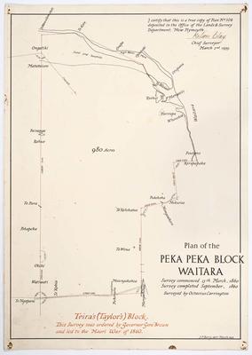
Plan of Peka Peka Block Waitara
Production date
1860
Description
Shows the survey ordered by Governor Gore-Brown and the land area known as Teira's block. 1860. Scale: 10 chain to 1 inch. Size: 64.5cm x 60.5cm.
See full details
Object detail
Part 1
Date: 1860
Scale: 10 chain to 1 inch
Size: 64.5cm x 60.5cm
Surveyor: O. Carrington
224.3 Encapsulation released for imaging June 2004. Manuscript mounted on linen. Pen and ink, coloured ink. J.F. Berry delt., 1939. Ink signature: Nelson Clay Chief Surveyor March 2nd 1939. To certify the map a true copy of SO Plan no. 104 deposited in Office of Lands and Survey Dept., New Plymouth.
Part 2
224.2 Original photostat created 24.11.1971
Part 3
224.5 Photocopy of 224.3
Part 4
224.6 Photocopy of Plan prepared for military purposes to obtain range of positions in terms with Headquarters Camp at Waitara. No. 113 in lower right corner. Office copy Nov.5th1860.
Photocopy created 21.11.1971

Public comments
Be the first to comment on this object record.