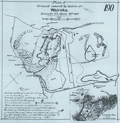
Plan of the ground covered by action at Waireka
Production date
1860
Description
Copy of a map drawn by W.E. Gordon showing the military routes and position, pa sites and redoubts that were part of the Battle of Waireka 28 March 1860. Scale: 20 chain to 1 inch. Size: 44.5cm x 46cm
See full details
Object detail
Part 1
Date:Undated
Scale: 20 chain to 1 inch
Size: 44.5cm x 46cm
Lithographer: W.F. Gordon
Photostat copy. Black and white. Copy has part of a stamp top right hand showing New Plymouth. Assumed to be Lands and Survey New Plymouth.
Part 2
Black and white photocopy A0. Can be used for reproduction.
Part 3
Black and white photocopy A3. Can be used for reproduction.

Public comments
Be the first to comment on this object record.