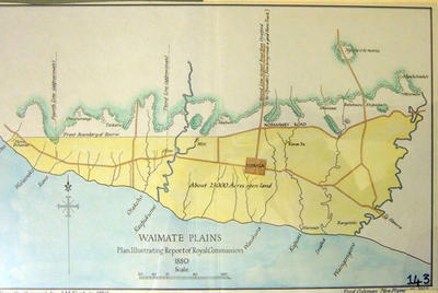
Waimate Plains. Plan illustrating Report of Royal Commission 1880
Production date
1937
Description
A manuscript copy of an earlier map by J.M. Kemp in 1880 of the Waimate Plains plan illustrating Report of Royal Commission 1880. Drawn by Fred Coleman, New Plymouth 1937 from an original by J M Kemp in 1880. 27.5cm H x 40.5cm W
See full details
Object detail
Part 1
Date: 1880
Scale: 80 chain to 1 inch
Size: 27.5cm x 40.5cm
Surveyor: J.M. Kemp
Cartridge paper. col. pen, ink and watercolour.

Public comments
Be the first to comment on this object record.