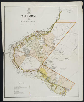
West Coast Plan of Confiscated Territory 1880
Production date
1880
Description
A published coloured lithograph of the Province of Taranaki showing Native Reserves; Awards to the Crown; Granted lands acquired by Government for sale or disposal; Constabulary stations; Native settlements, Lands returned to Native Tribes; Reserves proposed by Commission; Land disposed of by the Crown Land purchase; Native foot tracks. 1880.
Scale: 3 inches to 8 miles. Size: 59.5cm x 47 cm.
See full details
Object detail
Part 1
Date: 1880
Scale: 3 inches to 8 miles
Size: 59.5cm x 47 cm
Cartographer: Not known
Lithographer: Dangerfield, 22 Bedford St., Covent Garden.
Notes: Coloured lithograph. NZ Survey Map
109.1 Foxed and some splitting along folds. In Melinex.
Part 2
109.2 Chipping along edges. Removed from Melinex.
Part 3
109.4 Copy from Glass Case Collection.
Coloured photocopy of map. 1 A3 sheet.

Public comments
Be the first to comment on this object record.